The DJI Mavic 3 is an incredible flagship drone with professional imaging capabilities. Because of its excellent camera and high-resolution video capabilities, mapping scientists and certified photogrammetrists were particularly excited about this drone.
They were disappointed, to say the least!
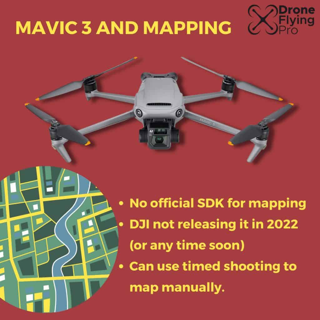
The DJI Mavic 3 does not have officially supported mapping capabilities. However, using cine mode and the hyperlapse feature, you may be able to achieve similar results to aerial mapping and photogrammetry.
Many people in the drone community think that DJI is making a huge mistake in not supporting mobile Software Development Kit (SDK) capabilities for waypoint mission planning.
However, it may be that DJI has attempted to define its product line more clearly by not allowing consumer drones to have professional product features.
The cynic in me thinks they want people to hand over much more money for these capabilities in professional machines.
Can DJI Mavic 3 be used for mapping?
According to DJI, they do not currently support mapping with the DJI Mavic 3.
Here is what they are saying in the online forums when the question is asked:
As of the moment, we do not have any information with DJI’s future update releases for the DJI Mavic 3 and with regards to this matter. Kindly please stay tuned to the latest updates by subscribing to DJI official website at www.dji.com or following us on social media (Facebook: https://www.facebook.com/DJI , Twitter: https://twitter.com/djiglobal , YouTube: https://www.youtube.com/user/djiinnovations ). Thank you.
DJI Support
They have not currently released a compatible Software Development Kit to enable the drone to be flown by third-party apps. Holding back on releasing the Software Development Kit means that there are no third-party means to automate the flight in a way that makes it perfect for mapping.
However, the DJI Mavic 3 does have a hyper lapse mode which is essentially the same as mapping and photogrammetry.
You can utilise a view of the inbuilt flight modes to achieve a result similar to mapping.
Mavic 3 mapping hacks
While people are waiting for the official SDK to be released, a few features can help professionals use the drone for mapping purposes.
The features include cine and hyperlapse mode.
Cine mode
To enter this mode, you simply flick the switch on the remote controller to the left.
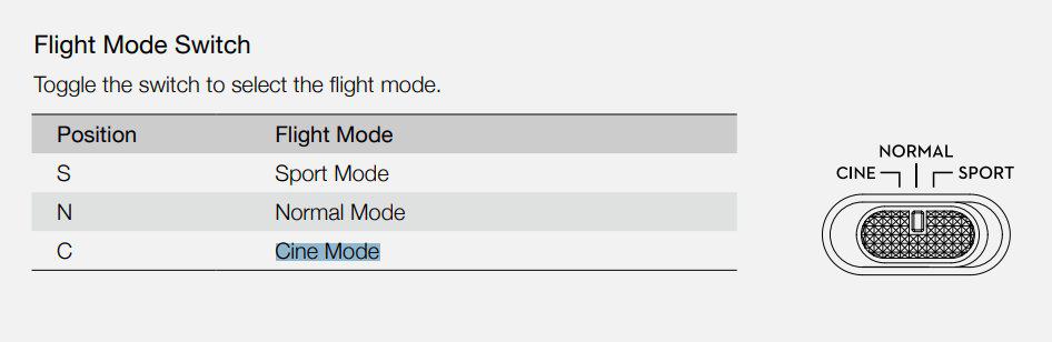
In cine mode, the flight speed is limited, making the aircraft much more stable during shooting.
The drone will move at 5 m/s.
A speed of 5 m/s makes it nearly perfect for mapping purposes.
Using cine mode combined with the timed shot feature may be the only way you can get mapping like functionality from the DJI Mavic 3.
However, there are also some modes that may help you automate some of the photography. The closest mode at the moment is hyperlase.
Hyperlase mode
This mode allows you to shoot at timed intervals whilst moving through a predetermined flight path.
The drone has four hyperlapse shooting modes: free, circle, course lock, and waypoint.
- Free – the aircraft will automatically take photos and generate a time-lapse video while you are flying.
- Circle – the aircraft will automatically take photos of flying around a selected subject to generate a timelapse video.
- Course lock – this can be used in two ways. In the first way, the orientation of the aircraft is fixed but a subject cannot be selected. In the second way the direction of the aircraft is fixed and the aircraft flies around a selected subject.
- Waypoints – the aircraft will automatically take photos on a flight path of 2 to 5 waypoints and generate a timelapse video. The aircraft can move from waypoints 1 to 5 or 5 to 1.
It is recommended to use high pillar mode at an altitude higher than 50 m, and to set a difference of at least two seconds between the interval time and shutter.
Manual flying
You can manually collect photos at a fixed altitude to produce your aerial map. Using the DJI Mavic 3 timed shooting function, you can take a picture as quickly as every two seconds.
You must ensure that there is a sufficient overlay of the photos that you take.
At least one-third of the total photo is recommended to overlap with the next.
If you want to see more about photogrammetry with the DJI Mavic 3 you can check out the work and experiments performed by Pix Pro. Click here to find out what they’ve been doing with timed photos and using the DJI Mavic 34 photogrammetry.
Does the Mavic 3 work with other popular programs?
The DJI Mavic 3 may work with other popular programs such as drone deploy and litchi. However, this relies on DJI making the Software Development Kit available to different manufacturers and developers of third-party piloting software.
The most recent news from DJI developer support is that they are prioritising enterprise level aircraft for development and that we shouldn’t expect any support for the DJI Mavic 3 series in 2022.
Here is what they had to say on their development support forum:

The MSDK is gradually prioritising to the enterprise level aircraft, the priority level of product from high to low is enterprise level aircraft > consumer level aircraft > handheld product.
- There is no plan to support Mini 3 Pro in 2022.
- There is no plan to support Mavic 3 consumer level series in 2022.
Therefore, we should not expect any official mapping capabilities to be added to the DJI Mavic 3 anytime soon.
So, what is the best drone for mapping if you cannot do it using the Mavic 3 Pro?
Here is what you need to know if you are serious about mapping and photogrammetry.
What is the best drone for mapping?
If you want to do mapping with your drone, one of the most respected drones is the DJI Phantom RTK.
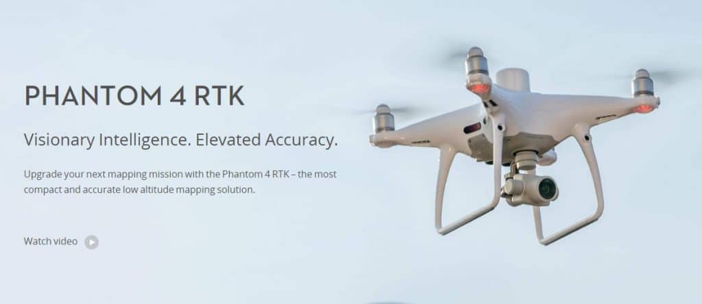
This drone has been built with surveying in mind and incorporates a 20-megapixel camera to give you sharp and detailed images from surveying heights.
In the RTK version, DJI has implanted a module that gives you centimetre-level positioning data for improved accuracy on image metadata. The satellite observation data is also stored for post-processed Kinematics that can be conducted using the DJI cloud PPK service.
To take full advantage of the positioning modules, the drone has a timeSync system to align the flight controller, camera, and Artie K module. The timeSync ensures that each photo uses the most accurate metadata and fixes the data’s positioning to the lens’s optical centre.
Wrapping up
In this article, we have looked at the Mavic 3 mapping capabilities and options available to you if you want to use this drone as a surveying tool.
Unfortunately, DJI has no plans now to add an SDK so that third-party applications can use it. However, using some of the inbuilt features, you can get mapping-like functionality.